Log in
All resources
Create a design
11,660 Free Images of Old Map
bibliothèque nationale de france
maps of spain by tomas lopez
baroque
maps in the library of congress
guillaume sanson
paper
british museum
maps by jakob van der schley
jakob van der schley
old maps of nuremberg
topographia superioris saxoniae, thüringiae, misniae et lusatiae (merian)
baroque
history of gostenhof
1708 in nuremberg
the turkish empire in europe, asia and africa (1752)
history of gəncə
maps of spain by tomas lopez
1768 maps of spain
old maps of the moon
johann georg heck
old maps of troyes
joachim duviert
prints from manesson travaux de mars at the peace palace library
old maps of brest from musée de bretagne
old maps of atlantis
island of california
old maps of the dutch gold coast
1818 maps
bali wars
buleleng
arnold's geographical handbook (1899)
maps of river clyde
maps in the british museum
old maps of norfolk
bibliothèque municipale de reims, rès. g 153
baroque
1708 in nuremberg
history of wöhrd
maps by jacques-nicolas bellin
1752 maps
maps in the british museum
old maps of leeds
old maps of asturias
1777 maps of spain
old maps of asturias
1777 maps of spain
old maps of asturias
1777 maps of spain
maps in the library of congress
1857 maps of pennsylvania
a popular history of the mexican people (1888)
reconstructions of old maps
old maps of limburg, netherlands
1884 in limburg (netherlands)
maps of africa in the robert c. williams paper museum
1702 maps of africa
atlas of the great elector
archipelagus orientalis
maps of the firth of forth
old maps of fife
old maps of the sinai peninsula
1870s maps of palestine
la virginea pars
secotan
old maps of the region of murcia
maps of spain by tomas lopez
old submaps of paris 5e arrondissement
turgot map of paris – derivative files
maps made in the 17th century
old maps of alsace
old maps of haarlem
museum haarlem
historical
history
history of university of amsterdam
old maps of amsterdam
old maps of norway
guillaume sanson
old maps of genoa
nicolò armanino
old maps of the kingdom of naples
maps by alexis-hubert jaillot
old maps of strasbourg
place broglie
old maps of brabant
guillaume sanson
maps of paris from the david rumsey historical map collection
1774 in paris
plan de la ville et faubourg de paris, divisé en ses 48 sections by mondhare & jean
maps of paris from paris musées
allgemeiner postatlas von der ganzen welt
old maps of england
maps in the british museum
william lodge
a treatise on ore deposits (1896)
1890s maps of saxony
maps from the earth and its inhabitants, vol. iv
old maps of the east riding of yorkshire
maps from the earth and its inhabitants, vol. iv
old maps of kingston upon hull
prints of italy in the universitätsbibliothek salzburg
wolf-dietrich-klebeband städtebilder
maps from university of amsterdam special collections
atlas der neederlanden
old maps of utrecht (city)
atlas van loon
1609 works in north rhine-westphalia
abraham hogenberg
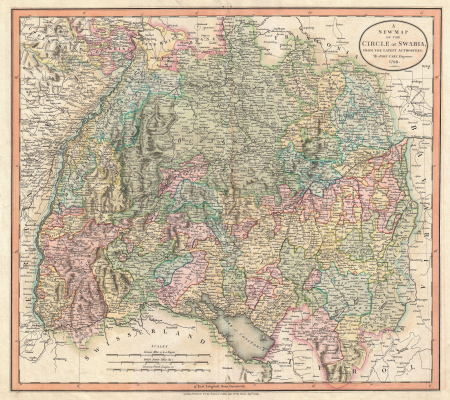
old maps of swabia
maps by john cary
flughafen köln-butzweilerhof
köln-bocklemünd/mengenich
maps from university of amsterdam special collections
caartboeck van voorne, 1701
1870s maps of the caucasus
g. h. swanston
old maps of georgia (u.s. state)
maps in the library of congress
1651 maps of baden-württemberg
house of helfenstein
maps from university of amsterdam special collections
atlas der neederlanden
steinfels collection
baroque
a voyage to abyssinia, and travels into the interior of that country, executed under the orders of the british government in the years 1809 & 1810
john outhett
maps by jakob van der schley
old maps of southeast asia
old maps of gelderland
isaak tirion
ramparts of châlons
city gates in marne
maps by jakob van der schley
old maps of southeast asia
a voyage to abyssinia, and travels into the interior of that country, executed under the orders of the british government in the years 1809 & 1810
john outhett
maps by daniel lizars
1820 maps of asia
maps from the earth and its inhabitants, vol. iv
old maps of the lake district
maps of spain by tomas lopez
old maps of menorca
guillaume-nicolas delahaye
jacques martin
arnold's geographical handbook (1899)
old maps of the amazon river
riga in the 17th century
old maps of riga
gemeente atlas van nederland - gelderland
old maps of huissen
engravings of topographia superioris saxoniae, thüringiae, misniae et lusatiae (merian)
baroque
historical
history
19th-century maps of maastricht
maps in hcl (maastricht)
nürnbergische kleider-trachten (1689)
old maps of nuremberg
old submaps of paris 2e arrondissement
rue louis-le-grand (paris)
arnold's geographical handbook (1899)
1899 maps of the united states
old maps of genoa
nicolò armanino
algiers in the 19th century
old maps of algiers
maps of brest, france by antoine aveline
brest (france) in the 1700s
maps of goa by linschoten
baroque
old maps of genoa
nicolò armanino
redeeming the republic (1890)
1890s maps showing history
atlas maior, vol 3 (germany) - joan blaeu, 1667 - bl 114.h(star).3
johannes gigas
1757 in north rhine-westphalia
old maps of wesel
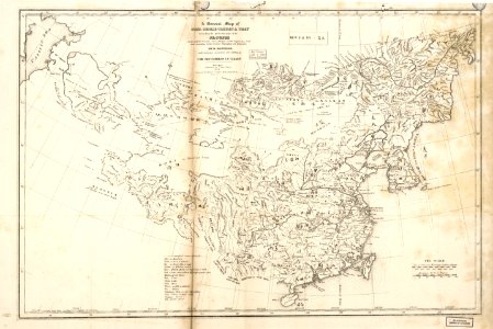
considérations géographiques et physiques sur les nouvelles découvertes au nord de la grande mer
1750s maps of the russian empire
old maps of atlantis
island of california
1660s maps of france
old maps of nevers
map of ancient assyria by philippe de la rué
old maps of mesopotamia
maps by pieter van der keere
1598 maps of italy
english-language maps of asia
maps by john cary
maps by pieter van der keere
old maps of gelderland
maps by willem and johannes blaeu
old maps of flanders
old maps of the london underground
maps by macdonald gill
palau in the 18th century
old maps of palau
1727 maps of africa
1720s maps of egypt
1727 maps of africa
1720s maps of egypt
lucas janszoon waghenaer
old maps of zeeland
bird's eye view of knoxville, tennessee, 1886
maps in the library of congress
old maps of the eastern hemisphere
1680s maps of the world
maps by jakob van der schley
old maps of southeast asia
9101 - 9200 of 11,660
Next page
/ 117


![The High Council of Delflant / according to order by Kruikius; [mapped by N. and J. Kruikius]; L. van Anse, T. Doesburch, Jac. et Joan. Deur, and P. Ruyter sculpt, 1712](https://cdn.creazilla.com/illustrations/10001543120/the-high-council-of-delflant-according-to-order-by-kruikius-mapped-by-n-and-j-kruikius-l-van-anse-t-doesburch-jac-et-joan-deur-and-p-ruyter-sculpt-1712-sm.webp)


![Caarte vande polder van Rugge A° 1696 / Heyman van Dyck fecit; A. Steyaart invenit; I. Stemmers sculpsit; I. Luiken fecit cum aqua forti, Romeyn de Hooghe, [1701]](https://cdn.creazilla.com/illustrations/10001404604/caarte-vande-polder-van-rugge-a-1696-heyman-van-dyck-fecit-a-steyaart-invenit-i-stemmers-sculpsit-i-luiken-fecit-cum-aqua-forti-romeyn-de-hooghe-1701-md.jpg)


![Special map of a part of Dutch Brabant, Guelders and Cleves or the surroundings of Grave, Ravestein, Helmont, Nijmegen, Fort de Schenk, Cleves, Gennip, Emmerick &c. / I. Condet f. 1748, Johannes Condet, [1748]](https://cdn.creazilla.com/illustrations/10000963180/special-map-of-a-part-of-dutch-brabant-guelders-and-cleves-or-the-surroundings-of-grave-ravestein-helmont-nijmegen-fort-de-schenk-cleves-gennip-emmerick-c-i-condet-f-1748-johannes-condet-1748-sm.jpg)